
In Forest Land: Special Places in the East Texas Pineywoods
Introduction
This exhibit explores a sense of place in the woods and waters of East Texas. The selection of places is random, but all the images were made in or near the Neches and Angelina river valleys. We hope you enjoy the images, as well as the interesting history of these special places in our part of Texas.
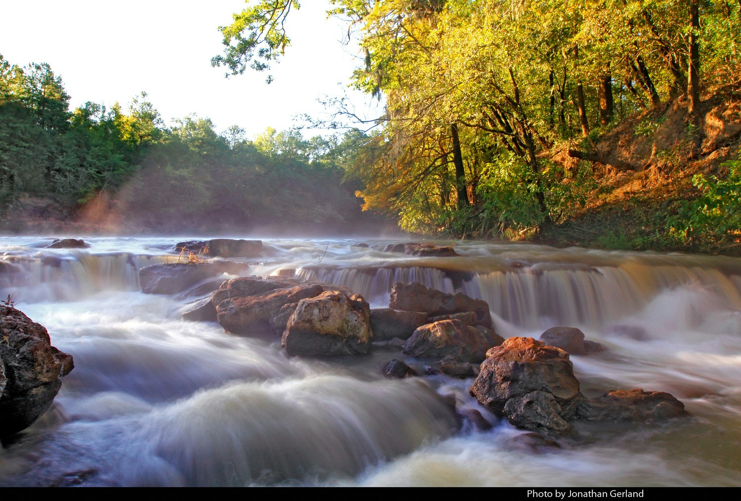
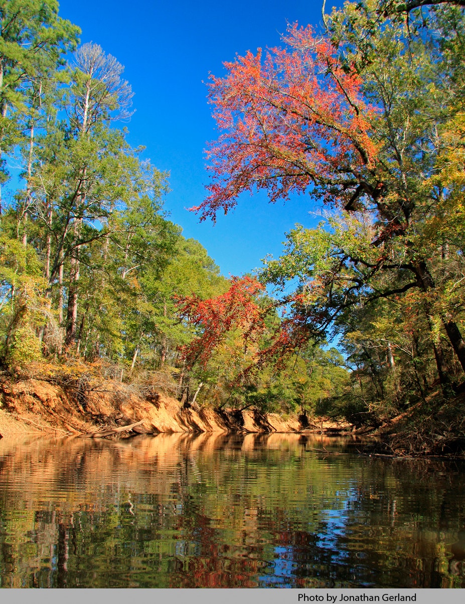
October Morning Mist on the Neches River
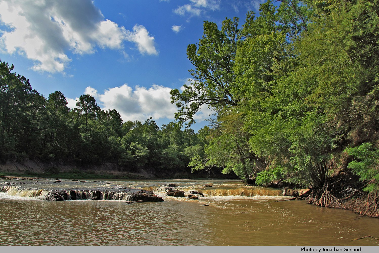
October morning mist rises from the Neches River at Rocky Shoals, near Rockland, in the Angelina National Forest. The waterfall is visible at times of low water, usually July through October, or anytime the water gage at the Rockland Station of the United States Geological Survey shows three feet or less. This photo made in October 2011, when the water level at Rockland was a little over two-and-a-half feet. The waterfall is almost precisely two river miles downstream from the US Highway 69 bridge. A paddling trip from the bridge to the falls, and back again, can be done at times of low water relatively easily.
Here is a video, made at the same time as the photo: http://www.youtube.com/watch?v=Z9JZZxMtn9U
Here is another video, made in September 2013: http://www.youtube.com/watch?v=J-rQ7LvKPbE

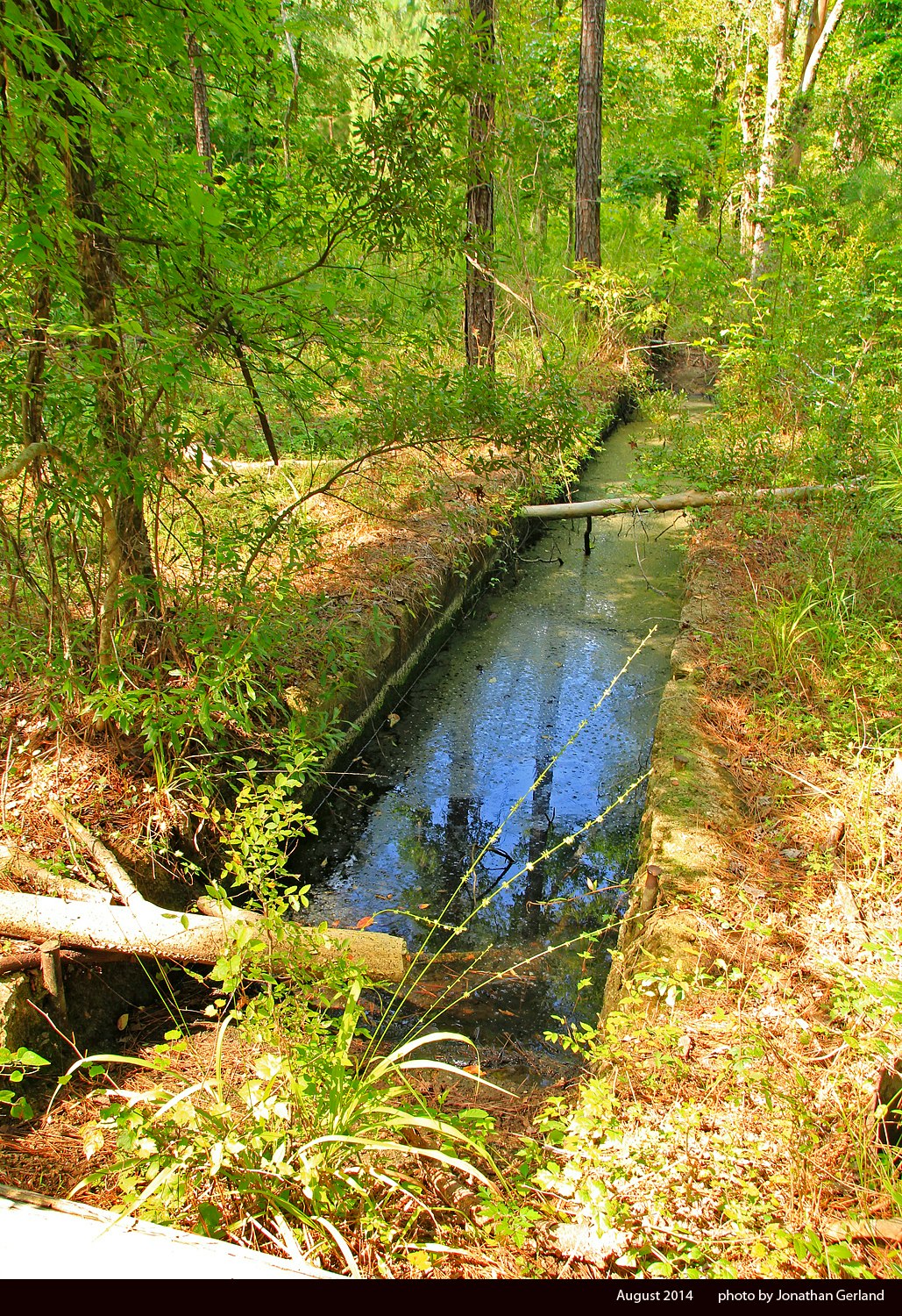
Neches River Waterfall at Rocky Shoals, Angelina National Forest
Another photo of the waterfall at Rocky Shoals, this time made in August 2014, when the Rockland water gage level reading was 3.14 feet.
Fort Teran Crossing, Neches River
The land just outside of this distinctive bend in the Neches River between Tyler and Jasper counties (just below the mouth of Shawnee Creek) once held an international border patrol station, manned not by Americans trying to keep out illegal immigrants from Mexico but by Mexicans trying to keep out illegal immigrants from the United States. For the fascinating history of this interesting time and place, see the article, “Remembering Fort Teran: A Mexican Outpost in the East Texas Pineywoods,” Pine Bough (December 2011): 2-19. This photo made in June 2011.

Hog Creek Falls East, a.k.a. Beef Creek Waterfall
Although publicized as Beef Creek Waterfall by Temple-Inland Forest Products Company during the 1990’s and 2000’s, this scenic 15-feet falls in northern Jasper County is actually located on one of Hog Creek’s numerous branches, which like nearby Beef Creek and its branches, are feeder streams to the Angelina River below Lake Sam Rayburn dam. Arthur Temple Jr. asked Temple-Inland foresters to protect the falls from any encroaching tree harvesting in 1986. Temple-Inland sold the distinctive site to The Campbell Group, a Timber Investment Management Organization, in the last quarter of 2007. The site was part of 1.15 million acres of Texas forests Temple-Inland sold to The Campbell Group. For a history of Temple-Inland's forest management in Texas, see the article, "A Brief History of Temple Land Ownership and Management in East Texas, 1893-2007," in The Pine Bough (December 2007): 8-33. This photo made in June 2007.
Hog Creek Falls West
Located a little more than six-tenths of a mile west of Hog Creek Falls East (a.k.a. Beef Creek Waterfall) by straight line distance, this smaller falls is just as refreshing on a hot summer’s day. This photo made in June 2007.
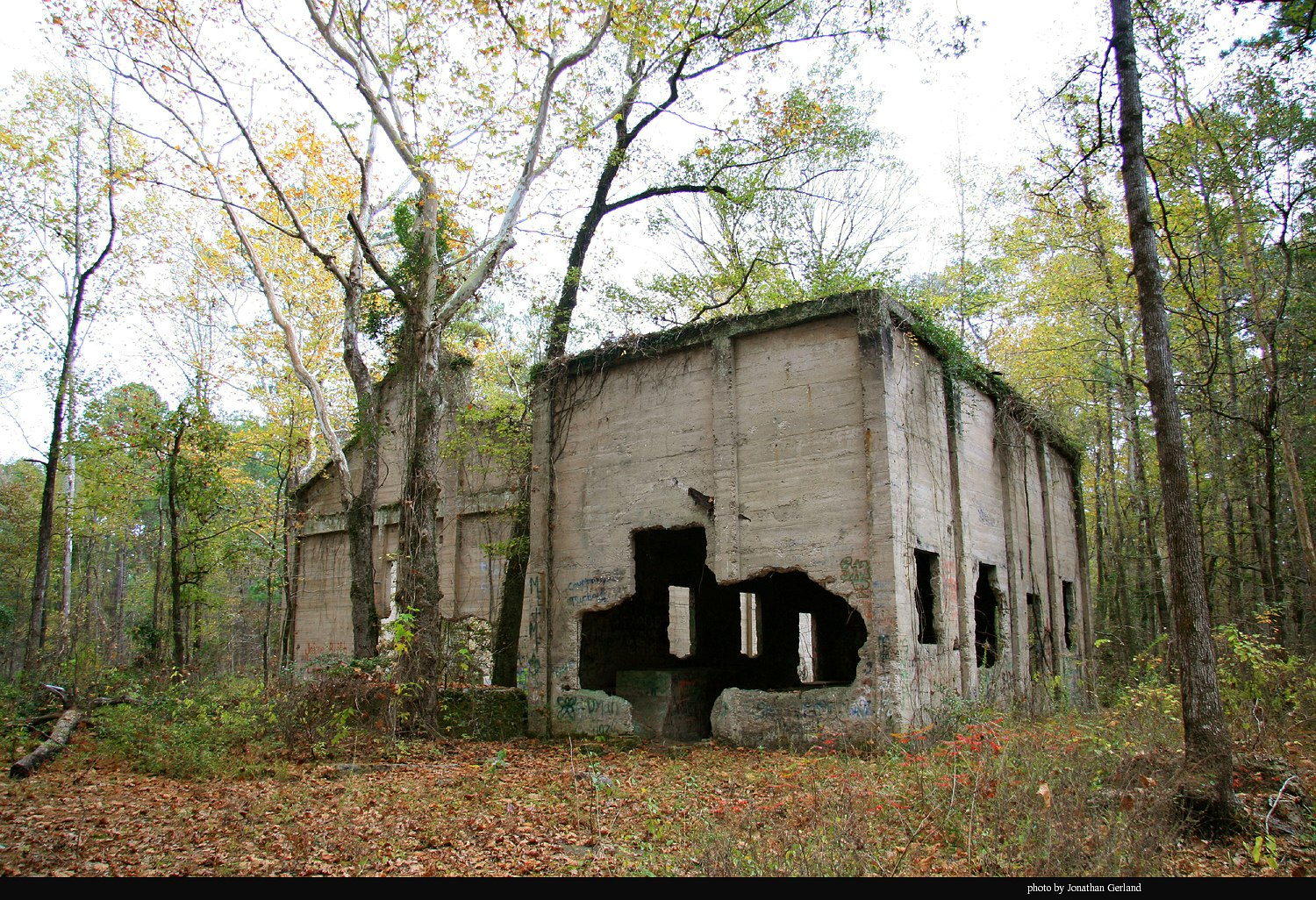
RUINS OF THE ALDRIDGE LUMBER COMPANY AT ALDRIDGE, TEXAS
Sycamores, pines, and a host of other trees have reclaimed the once thriving commercial center known as Aldridge, Texas, in northern Jasper County, on the banks of the Neches River. These ruins are only about 220 yards from a bluff overlooking the Neches, although the woods today are thick enough to easily obscure the view. Plagued by devastating mill fires, a large sawmill complex operated here for only nine years, from 1906 to 1915, while smaller mill operations at or near the site continued into the 1920’s. Nearby was also a large turpentine camp, known as Turpentine. For a history of the site, the surrounding area, and the interesting relationship between lumbermen John Henry Kirby and William Hal Aldridge, see the article, “A Sense of Place in the Angelina National Forest: Aldridge, Blue Hole, Bouton Lake, Boykin Springs, and Turpentine” in The Pine Bough (December 2009): 2-27. This photo made in November 2009.

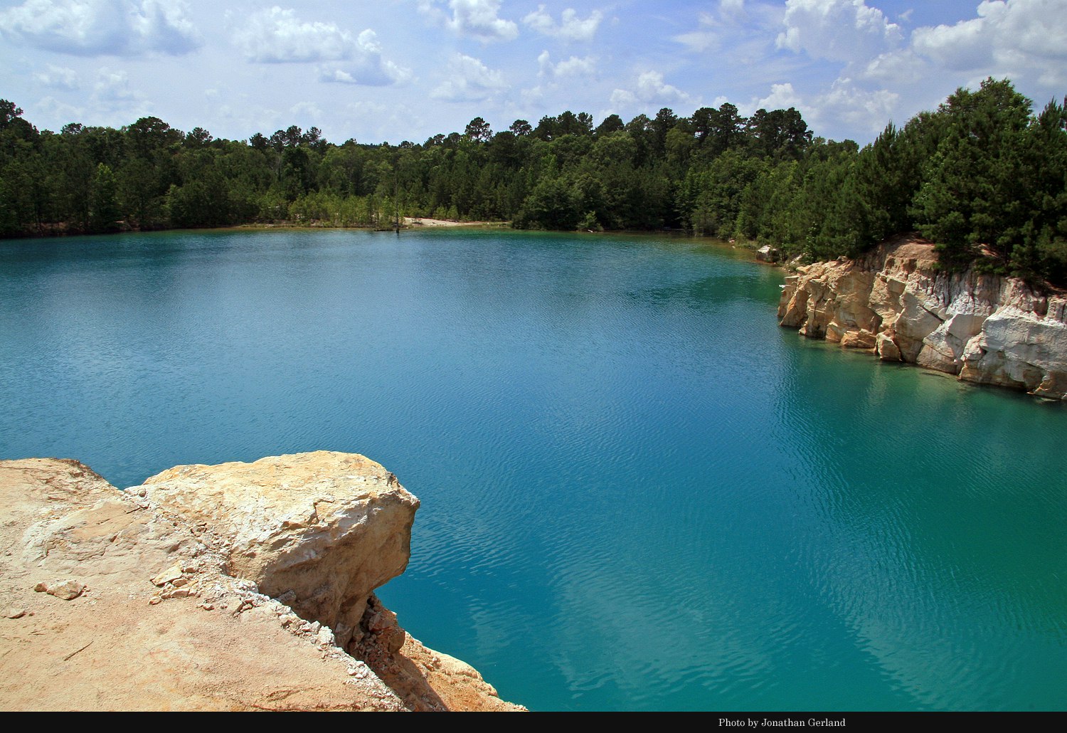
Blue Hole, Jasper County
Located on a private inholding within the Angelina National Forest in upper northwestern Jasper County, "Blue Hole" is a former sandstone rock quarry that flooded during the 1920’s and became a unique and at times popular swimming hole for the area. The quarry opened in 1893 to supply rock for construction of the Sabine Pass jetties extension, and a standard gauge railroad was constructed from Rockland to the quarry in 1895-1896, linking quarries on both sides of the Neches River to mainline rail connections at Rockland. The road was originally chartered as the Rock Quarries Tram Road and later, in 1905, as the Rockland, Jasper & Northeastern Railway Company. John Henry Kirby acquired the railroad in 1906 and reorganized it as the Burr’s Ferry, Browndel & Chester Railway. For more information about The Blue Hole and the surrounding area, see the article, “A Sense of Place in the Angelina National Forest: Aldridge, Blue Hole, Bouton Lake, Boykin Springs, and Turpentine,” in The Pine Bough (December 2009): 2-27 and the article, “Helen Darden’s Memories of the Blue Hole, the Vernon County Line School, and the Boykin Community” in The Pine Bough (December 2011): 20-25. This photo made in June 2007.
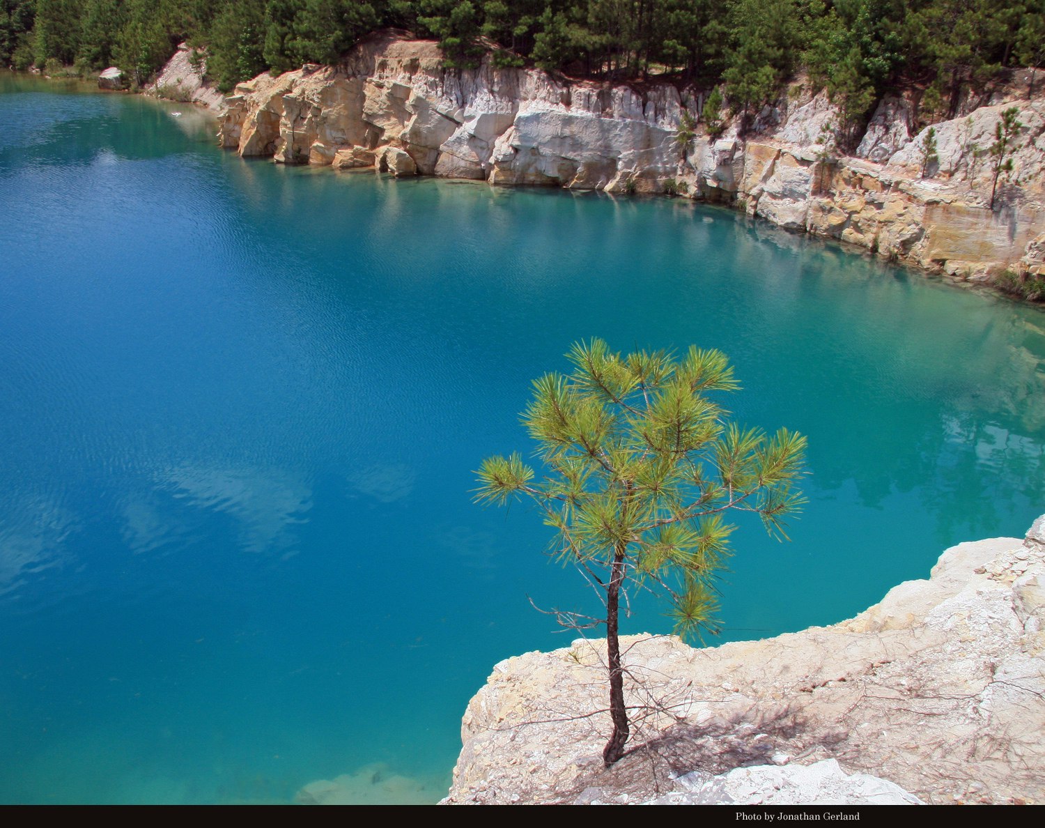
THE BLUE HOLE IN JASPER COUNTY
Another view of the Blue Hole in Jasper County, in June 2007. Before the quarry filled with clear spring water, the site was known as Kyle’s Quarry (named for William Wesley Kyle of Beaumont). When noted geologist Edwin T. Dumble published his University of Texas Bulletin, “The Geology of East Texas,” in 1918, he described Kyle’s Quarry as being in a deposit of “quartzitic” sandstone of the Corrigan (or Catahoula) geologic formation. He reported that after removing ten to twelve feet of Lafayette overburden, the quarry was yielding the desired sandstone rock from a layer of thirty-five to forty feet thick. “The hard rock is very light gray or gray blue in color…made up mainly of quartz and chert,” he wrote. “It contains angular fragments of hard whitish and greenish clays.” It is believed the coloring of the clays and rock, as described by Dumble, is what gives the Blue Hole’s deep waters their distinctive blue-green color.
THE BLUE HOLE
And another view of the Blue Hole in Jasper County, June 2007. Longtime Dallas Morning News columnist Frank X. Tolbert wrote about The Blue Hole frequently from the late 1950’s through the early 1970’s. “It is as pretty a spot as you’ll find in the hemisphere,” he told his readers in 1960. He especially enjoyed swimming, sometimes nude, he said, in the “brilliantly colored waters” surrounded by white sandstone cliffs and shady green pines. Several times he gave detailed driving directions to this “jewel of the East Texas forests.” Other swimmers apparently did not need much encouragement, for by the early 1970’s traffic had increased and Tolbert was disappointed to find “mounds” of discarded beer cans and bottles during his visits, which he said “defiled” the place. Tolbert also was one of the first writers to dispel a long held legend which said a lost locomotive and one or more rail cars rested deep at the bottom of the hole. He reported in a January 1960 article that the lake had been recently drained by engineers working on the Lake Sam Rayburn dam. All they found, he said, were “a few small perch.” He said divers had earlier disproved the “ancient yarn” and “beloved East Texas legend” but “some folks weren’t convinced until the inky waters were drained.” The Blue Hole soon refilled, and remains so today, giving life again to the legend of the lost train.
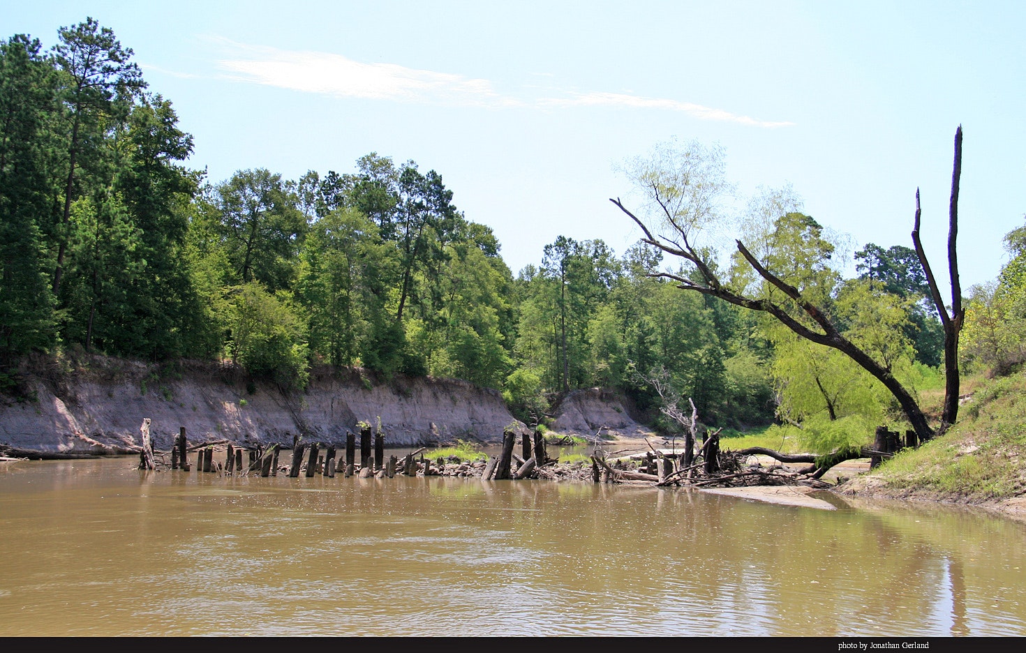
Burr's Ferry, Browndel & Chester Railway Pilings in the Neches River
Abandoned pilings of the Burr’s Ferry, Browndel & Chester Railway (BFB&C) still stand in the Neches River channel between Tyler and Jasper counties, near Aldridge. The Rock Quarries Tram Road, a standard gauge railroad, first bridged the river here in 1895-1896. The road linked sandstone rock quarries on both sides of the Neches River to mainline rail connections at Rockland, from where the sandstone rolled south to Sabine Pass to be used in the federal government’s jetties extensions in Jefferson County. The railroad reorganized as the Rockland, Jasper & Northeastern Railway Company in 1905, before John Henry Kirby acquired the operation, changing the name to BFB&C in 1906 and extending the line to the new sawmill town of Aldridge and the turpentine camp town known as Turpentine, both of which had post offices into the 1920’s. Southern Pacific bought the BFB&C in 1912 and operated it until 1927. After that time the railroad may have served as an unincorporated logging line into the 1930’s. For more on the railroad’s interesting history, see the article, “A Sense of Place in the Angelina National Forest: Aldridge, Blue Hole, Bouton Lake, Boykin Springs, and Turpentine” in The Pine Bough (December 2009): 2-27. This photo made in July 2009.
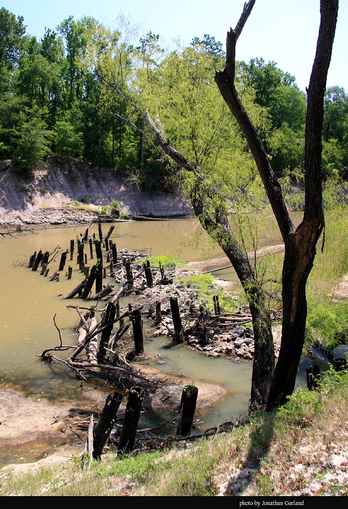
Burr's Ferry, Browndel & Chester Railway Pilings
Another view of the BFB&C Railway pilings in the Neches River, looking northeastward from Tyler County into Jasper County. The approximate coordinates of this location are 31 degrees, 2 minutes, and 12.5 seconds North and 94 degrees, 20 minutes, and 16.3 seconds West. The location is southwest of the Blue Hole, about one-and-a-half miles straight line distance from the Blue Hole. This photo made in July 2009.
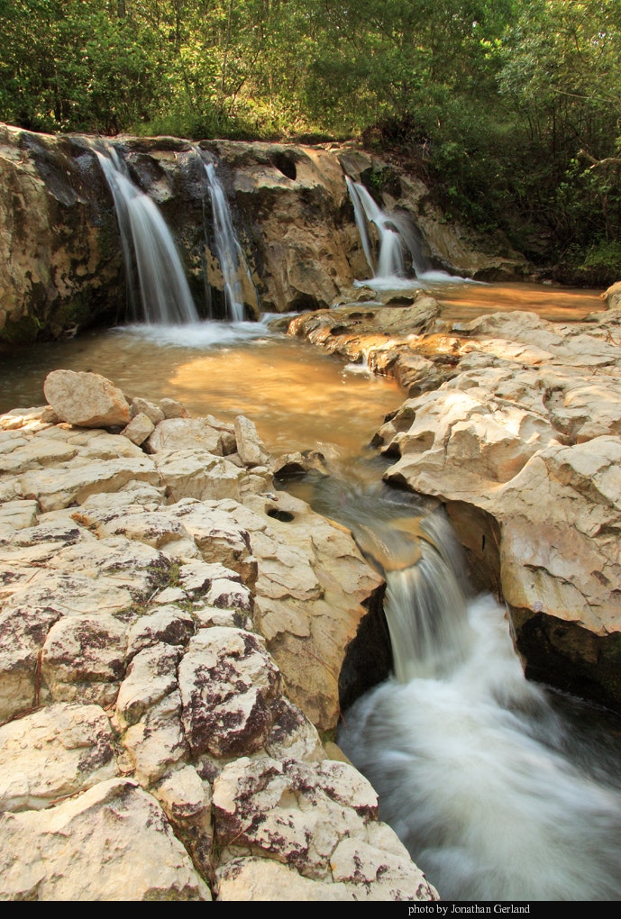
Boykin Creek Waterfall, Angelina National Forest
This refreshing waterfall on Boykin Creek greets travelers along the Sawmill Hiking Trail, near the trailhead at Boykin Springs Recreation Area, south of Boykin Lake. This photo made in November 2008.
Developed and constructed by the Civilian Conservation Corps in the 1930’s, Boykin Springs Recreation Area is an excellent place to visit, as are most CCC projects across the country. The area includes a lake for swimming and fishing, a bathhouse, camping sites, picnic tables, a pavilion, the Sawmill Hiking Trail, and beautiful pine forests.
Boykin Springs has long been a popular encampment for all kinds of youth gatherings, including the Boy Scouts of America and the Future Farmers of America. In the early 1940’s, FFA groups of 400 to 500 boys, representing two dozen East Texas high schools, participated in three-day summer camps. Activities included swimming, boxing, softball, horseshoe pitching, checkers, dominoes, volleyball, washer pitching, ping pong, tug-of-war, and musical entertainment. In 1942, seven East Texas companies of the 44th Battalion of the Texas Home Defense Guard participated in combat training maneuvers at Boykin Springs and in the surrounding forest. About this time, even a nearby practice aerial bombing range was included in the World War II training.
For many years the forest service partnered with the Texas Parks & Wildlife Department in stocking rainbow trout in the Boykin Springs Lake and in Boykin Creek. Several stockings a season of 8 to 10 inch trout usually occurred from late December into February, when target water temperatures are 60 degrees or lower. During the middle 1970s each season’s initial stocking included more than 3,000 trout in the lake and another 1,100 in the creek.
Boykin Springs, as well as Boykin Creek, is named for Sterling Boykin (1800-1871), who settled the area before the Civil War and is buried within the campground. The small Boykin Cemetery is fenced on a small hill near some of the springs.
Lufkin author Richard Donovan described Boykin Springs during a 1999 canoe expedition as “a masterpiece of human skill at melding together nature’s components of water, trees, and rocks to form a superb recreation area.” Since that time, Hurricane Rita greatly impacted the area in September 2005. Uprooted and fallen trees caused significant damage to most structures, including destruction of the original rock spillway. After considerable tree removal and structural rebuilding, the area reopened to the public in fall 2008. Although greatly changed from its former beauty, the area remains among the favorite places of many East Texans.
Here is a video of the falls, made in February 2014: http://www.youtube.com/watch?v=N1Z4HbJaEHw

Bouton Lake, Angelina National Forest
Outside of myth and legend, little is known about this twelve acre natural lake that appears almost boat-shaped in aerial photographs and seems always placid. It is presumably named for Nathan Bouton, who in 1854 patented the land upon which the lake rests. It has long been a camping and fishing destination, especially during the days of the Aldridge sawmill operations.
When lumberman John Henry Kirby entertained here, he usually gave specific instructions to Hal Aldridge concerning supplies and arrangements. For a week-long camping trip at the lake in early May 1906, Kirby instructed Aldridge about two months in advance to construct “two or three wide bottomed skiffs” as well as a raft made from “dead logs…with a floor on it and let the ladies fish.” Kirby advised there would be 40 to 50 people in the party, including about 10 servants, and he directed Aldridge to hire a “man cook as it is no light job to cook for this many people.” Kirby would send tents, stoves, dishes, bedding and other supplies from Houston, but he wanted Aldridge to provide barrels of fresh drinking water and “to arrange with some of the citizens in the neighborhood, if there are such, for milk, butter, eggs, chickens, onions, radishes, and other vegetables,” since “it will take quite a lot to feed as many hungry fishermen as we shall have with us.”
The U.S. Forest Service developed Bouton Lake Campground in the early 1960’s. It is a no-fee area that provides visitors with picnic tables, primitive camping, fishing, and hiking amid a bottomland hardwood and cypress forest. The west side of the lake is private property. This photo made in November 2009.
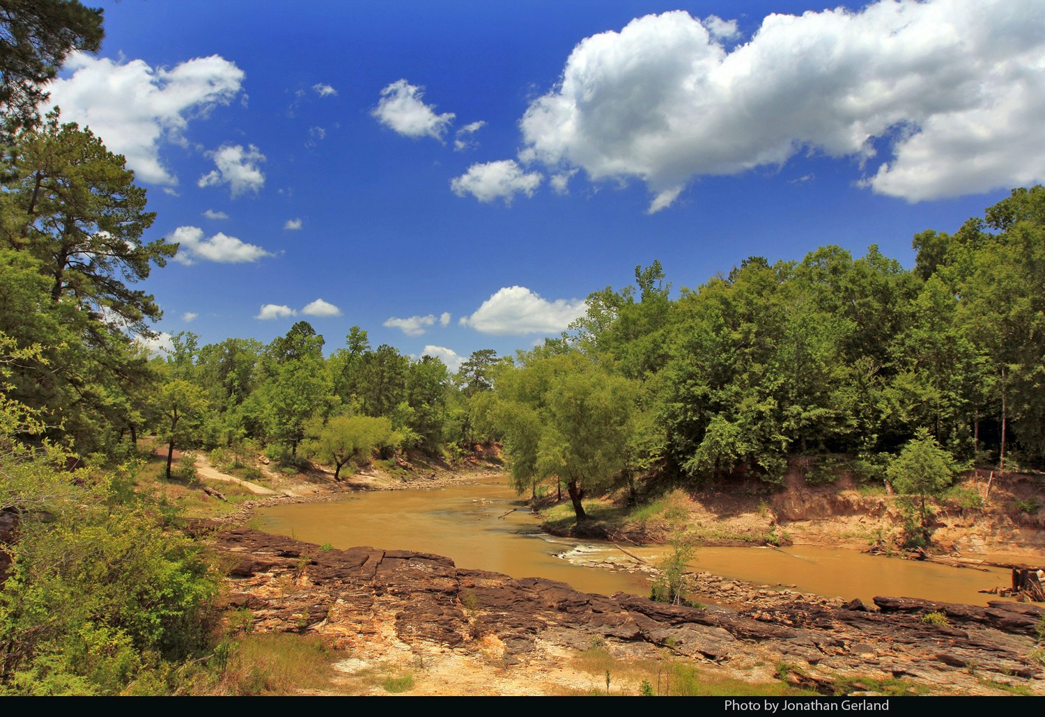
Rocky Shoals Waterfall, Neches River
Another view of the waterfall at Rocky Shoals, near Rockland, in the Upland Island Wilderness Area of the Angelina National Forest. During times of low water flow (usually middle summer though early fall), the Neches River cascades here over sandstone rocks and hard clays of the Catahoula geological formation. The Neches River flows predominantly from west to east here, being deflected by a large sandstone ridge known geographically as the Kisatchie Wold, which extends from the Mississippi River floodplain to the Rio Grande valley, roughly paralleling the Gulf of Mexico. The eastward deflection of the Neches, forming the northern boundaries of Polk and Tyler counties, is one of the most distinctive features of the formation in the state. This photo made in July 2009.
Angelina River, Home of the Hainai Indians
The land around the Angelina River between Nacogdoches and Cherokee counties was the home of the Hainai tribe of the Hasinai Indians during the 17th and 18th centuries. Spanish and French explorers, traders, and priests found a Spanish speaking Indian woman living among the Hainai in the 1710’s and 1720’s, whose name was Angelina (in Spanish) and Angelica or Angelique (in French). Written sources of that day say that she served as an interpreter between her people and the Europeans. By the middle 18th century the Spanish named the river near her village in her honor and in 1846 citizens of the United States named Angelina County for her as the only county in Texas named for a woman. For more information about Angelina, see the article, "Finding Angelina: The Search for East Texas' Little Angel," The Pine Bough (December 2012): 12-21. This photo was made in November 2012 from a kayak upriver from Goodman’s Bridge.
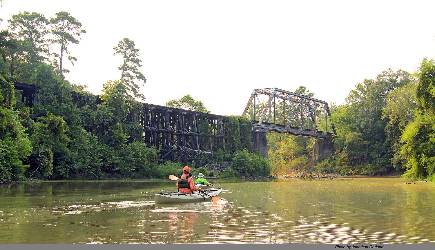
Abandoned Railroad Bridge Over the Neches River at Rockland
Kayakers glide toward the abandoned Texas & New Orleans railroad bridge over the Neches River north of Rockland in September 2013. The bridge was constructed in 1899-1900 and was abandoned in about 1996.
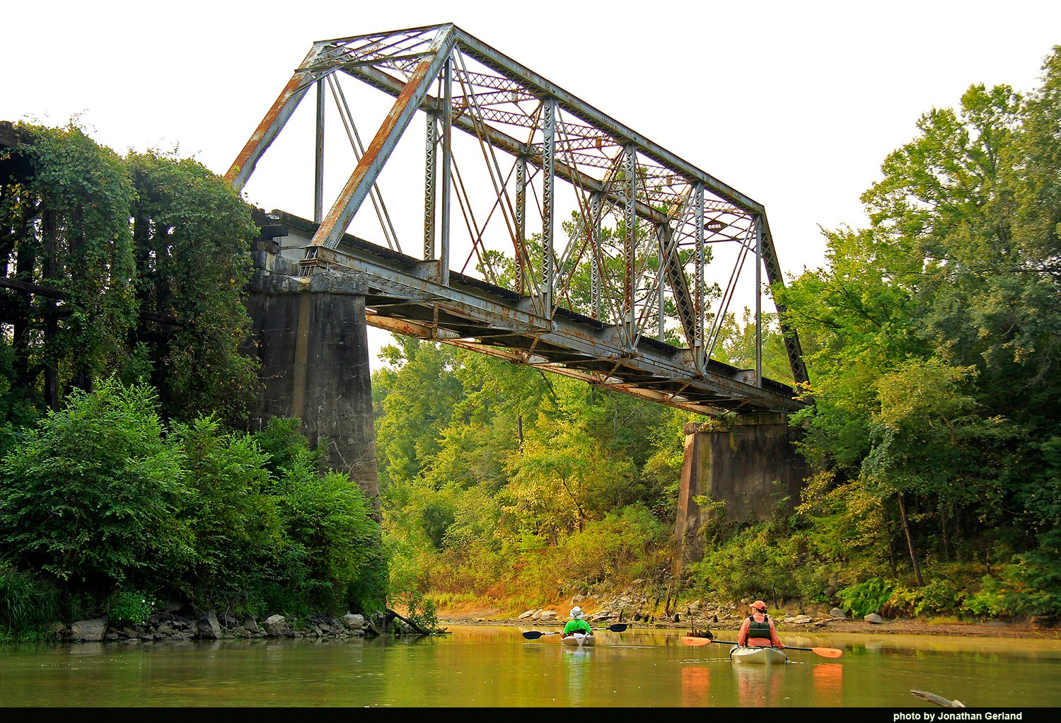
Railroad Trestle and Bridge Over the Neches River at Rockland
Another view of the abandoned railroad bridge over the Neches River near Rockland. The bridge is located eight-tenths of a mile downriver from US Highway 69.
Texas State Railroad Engine 300 Crossing the Neches River
The Texas State Railroad began in 1882 as a decision by Governor Oran M. Roberts to construct 1.3 miles of railroad between the state's new East Texas Penitentiary and the tracks of the Kansas & Gulf Shortline (K&GSL) railroad at Rusk. The spur was necessary to provide significant amounts of fuel to the prison's charcoal-fired iron smelting furnace and also provide an outlet for heavy iron products manufactured at the prison. Although built by the state, the spur was operated by K&GSL until 1886, when the state, under Governor John Ireland's direction, purchased a second-hand locomotive and began independent train operations. In 1893 Governor James Hogg initiated the state's construction of a branch line railroad from the prison to Palestine, completing 9 miles by 1896, but stopping short of the Neches River. Texas abandoned 6 miles of this extension in 1903 and began construction of a new route, reaching the present site of Maydelle in 1904. Between 1907 and 1909, under push from Governor Thomas M. Campbell, the state exercised power of eminent domain and finally completed the Palestine objective initiated 16 years earlier.
Unlike other state-owned and operated railroads in Brazoria, Fort Bend, and Walker counties, the 33 mile Texas State Railroad between Rusk and Palestine organized under special legislation in 1907 as a common carrier of public freight and passengers. As such, civilians composed all operational train and regular maintenance crews. Between 1910 and 1920 the Rusk-Palestine operation regularly employed between 36 and 70 civilians monthly, paying wages comparable to private railroad companies in Texas operating over similar distances. Because of construction cost overruns and almost annual "emergency" operational appropriations, the State Railroad was quickly identified by legislators as "a white elephant on the hands of the state." To mitigate further losses, Texas leased the line to private railroad companies, including Texas & New Orleans, Texas Southeastern, and Missouri Pacific, between 1921 and the early 1970s, then transferred it to the Texas Parks & Wildlife Department in 1972. The line reopened to the public as a State Historical Park in 1976, providing steam passenger tourist excursions seasonally. * Based on Jonathan Gerland's STEAM IN THE PINES: A HISTORY OF THE TEXAS STATE RAILROAD (Nacogdoches: East Texas Historical Association, 2004)
Walkerton Cattle Dipping Vat (Houston County)
This is one of two concrete dipping vats remaining at the former Rayville Ranch, now part of Boggy Slough Conservation Area. Walkerton was the site of a Southern Pine Lumber Company logging camp from 1910 to 1913, located one-and-a-quarter miles northwest of Mt. Pisgah School and Cemetery (just south of today’s Highway 7, three-and-a-quarter miles west of the Neches River). The camp served Southern Pine’s pine and hardwood sawmills at Diboll, in Angelina County, and was named for Watson Walker, Diboll’s manager. After removing all merchantable trees in the area, Southern Pine fenced 30,000 acres of cut-over lands (including land north of highway 7 and south all the way to highway 94) and established a large cattle ranch in Trinity and Houston counties in 1913, in an attempt to demonstrate the conversion of cut-over lands to grazing lands, while waiting for a “second crop” of young pines to mature. Named for rancher John Jones Ray, Rayville ran a regular herd of 2,000 adult cows of local stock crossed with Brahman bulls to produce calves with hybrid vigor especially suited to the pine-hardwood range. To control emergent underbrush and create more pastures, the ranch also raised several thousand head of Spanish goats. In time, through experience and the urgings of newly trained foresters of the U. S. Forest Service and Texas Forest Service, Southern Pine officials ceased ranching operations in 1932 and adopted sustainable forestry practices, although a cattle grazing lease of the former ranch, made to Southern Pine’s head of the land and timber department, Dave Kenley, continued on the land into the 1960’s. The Walkerton dipping vat is believed to have been constructed shortly after 1913 and was in active use through the 1950’s, located on the tracks of the Texas Southeastern Railroad . The land is now owned by the T. L. L. Temple Foundation and is part of the 19,000 acre Boggy Slough Conservation Area. —by Jonathan Gerland.